| 1. |
_________ are responsible for insuring safe operating procedures by crew members, instructing crew members on safe work practices, enforcing safety policy, and setting a positive example. |
|
|
Safety officers |
|
|
Survey Crew Chiefs |
|
|
Survey Supervisors |
|
|
Survey advisor |
| 2. |
While the Department may have a legal right to enter private property, it is important for the surveyor to use courtesy when doing so. |
|
|
True |
|
|
False |
| 3. |
Which of the following is not a safety equipment? |
|
|
First aid Kit |
|
|
Fire extinguisher |
|
|
Compass |
|
|
Safety vest |
| 4. |
The __________ of a control point is a value that represents the uncertainty in the coordinates of the control point relative to the coordinates of other directly connected, adjacent control points at the 95-percent confidence level. |
|
|
local accuracy |
|
|
network accuracy |
|
|
overall accuracy |
|
|
point accuracy |
| 5. |
__________ also referred to as Stand Alone, Point, or Absolute Positioning. GPS method by which only one receiver is employed, position is determined from satellite observations only. Accuracy of about 30 ft (10 meters). Recreational GPS receivers rely on this method. |
|
|
Differential positioning |
|
|
Autonomous Positioning |
|
|
Carrier phase positioning |
|
|
Real time positioning |
| 6. |
New York State Plane Coordinate System (NYSPCS) is made up of 4 zones. Which of the following is not one of them? |
|
|
West |
|
|
Central |
|
|
East |
|
|
North |
| 7. |
The GPS processing software will calculate convergence angles and combined factors. Combined factor = ________________ ? |
|
|
(grid scale factor x ellipsoidal reduction factor) |
|
|
(grid scale factor + ellipsoidal reduction factor) |
|
|
(grid scale factor/ellipsoidal reduction factor) |
|
|
(grid scale factor – ellipsoidal reduction factor) |
| 8. |
The ____________ responsible for the work shall assure that field procedures are consistent with the NGS specifications for the desired classification. All field work shall be checked for internal accuracy. All documentation shall be checked for completeness, accuracy and format. |
|
|
Licensed Contractor |
|
|
Licensed Crew manager |
|
|
Licensed Land Surveyor |
|
|
Licensed Field officer |
| 9. |
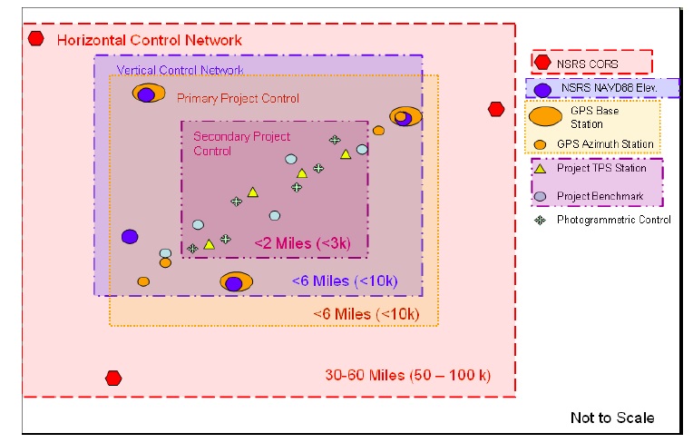
What does the following picture depicts?
|
|
|
NYSDOT Network Control Projects |
|
|
NYSDOT Survey Control Classifications |
|
|
NYSDOT Network Control Diagrams |
|
|
None of the above |
| 10. |
To qualify for adjustment, level line (differential, trigonometric or GPS) error shall not exceed ___________ where D is the length of the level line in miles. |
|
|
.03 ft*√D |
|
|
.03 ft/√D |
|
|
.05 ft*√D |
|
|
.03 ft+√D |
| 11. |
The primary project control is used to establish secondary project control within the project area, to control the engineering and real property acquisition work required for a project. |
|
|
True |
|
|
False |
| 12. |
When the term __________ is used in this NYDOT manual it refers to the ground control targets or photo identifiable points occurring within the area of a project. |
|
|
Photogrammetric control |
|
|
Network control |
|
|
Vertical control |
|
|
None of the above |
| 13. |
What does DTM stand for? |
|
|
Digital triangular model |
|
|
Direct terrain model |
|
|
Digital terrain model |
|
|
None of the above |
| 14. |
Which of the following are poorly defined features? |
|
|
Erosion Control Features |
|
|
Geotech Features |
|
|
Traffic Control Features |
|
|
All the above |
| 15. |
Surveying any rock face is easy and do not have any potential safety problems or issues. |
|
|
True |
|
|
False |
| 16. |
Roadway buffer features are ___________ ? |
|
|
curb |
|
|
guiderail |
|
|
driveways |
|
|
All of the above |
| 17. |
All property line and highway boundary field evidence for ROW Surveys shall be located directly from secondary project control using a TPS and radial surveying techniques. What does TPS stand for? |
|
|
Total Survey Positioning System |
|
|
Total Station Positioning System |
|
|
Total Station Projectioning System |
|
|
None of the above |
| 18. |
Photogrammetric mapping methods cannot capture all of the information requested by design about the existing situation in a project area. Photo mapping only can capture every feature visible from a vantage point of about _________ straight up. |
|
|
1100 ft. |
|
|
1300 ft. |
|
|
1500 ft. |
|
|
1700 ft. |
| 19. |
All survey equipment, including tripods, tribrachs, prisms, etc. shall be properly maintained and calibrated frequently according to manufacturers’ guidelines. |
|
|
True |
|
|
False |
| 20. |
The order of importance of project control is
- Secondary Project Control Stations
- National Spatial Reference (NSRS) Stations
- Primary Project Control Stations
|
|
|
1-2-3 |
|
|
2-3-1 |
|
|
1-3-2 |
|
|
3-2-1 |
|