| 1. |
Permit-required confined space means a confined space that does not contain any physical hazards or any actual or potential atmospheric hazards capable of causing death or serious physical harm. |
|
|
True |
|
|
False |
| 2. |
The word safety can be interpreted in many different ways. To some it can mean to be free from injury, to others it means to be secure from danger. These are both good definitions, but the one WSDOT likes best is _______? |
|
|
The giving of life. |
|
|
The giving of First aid. |
|
|
The giving of protection. |
|
|
The giving of Hard hats. |
| 3. |
Which of the following is not surveying equipment? |
|
|
Clinometer |
|
|
Automatic level |
|
|
Umbrella sun shade |
|
|
None of the above |
| 4. |
The use of a _________ in the recording of field terrain information requires attention to standard survey practices to ensure accuracy. |
|
|
Data controller |
|
|
Data interpreter |
|
|
Digital controller |
|
|
None of the above |
| 5. |
To establish where the Public Lands Survey System (PLSS) lines intersected the boundary line, auxiliary corners were set, known as _____________? |
|
|
Public corners |
|
|
Witness corners |
|
|
Government corners |
|
|
none of the above |
| 6. |
What is H in the following figure?
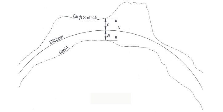 |
|
|
Ellipsoidal height |
|
|
Geoid height |
|
|
Orthometric height(elevation) |
|
|
None of the above |
| 7. |
Random errors do not follow any fixed relationship to conditions or circumstances of the observation. |
|
|
True |
|
|
False |
| 8. |
Which of the following is not a GPS survey method? |
|
|
Static GPS Surveys |
|
|
Fast-Static GPS Surveys |
|
|
Fast-dynamic GPS Surveys |
|
|
Kinematic GPS Surveys |
| 9. |
A loop is a series of at least ________ independent, connecting base lines that start and end at the same station. |
|
|
Two |
|
|
Three |
|
|
Four |
|
|
Five |
| 10. |
Survey specifications describe the methods and procedures needed to attain the desired survey standard and TSS is a Survey Specification method. What does TSS stand for? |
|
|
Total Survey System |
|
|
Time Specific System |
|
|
Total Station System |
|
|
None of the above |
| 11. |
___________ are a series of permanent points of known elevation located within the limits of the project. |
|
|
Benchmarks |
|
|
Trademarks |
|
|
Accessmarks |
|
|
None of the above |
| 12. |
Point of compound curvature – Point common to two curves in the same direction with different radii. |
|
|
True |
|
|
False |
| 13. |
________ surveys are used for reconnaissance, location design, PS&E, and construction projects. They are used for mapping, digital terrain modeling, cross sectioning, and alignment determination. |
|
|
Photogrammetric |
|
|
Photographic |
|
|
Graphic |
|
|
None of the above |
| 14. |
Prior to initiating a Control Survey a thorough search and recovery of existing horizontal and vertical control monuments in the immediate area of the project is required. |
|
|
True |
|
|
False |
| 15. |
The _______ is an engineer who leads the Project Development Team and is responsible for overall project planning and completion. |
|
|
Project Scheduler |
|
|
Project Director |
|
|
Project Manager |
|
|
Project Supervisor |
| 16. |
________ is a trial and error process of finding the point where the slope intercepts the natural ground. This point is referred to as the "catch point" or "slope catch." |
|
|
Slope staking |
|
|
Point staking |
|
|
Point catching |
|
|
None of the above |
| 17. |
A _________ is an opening (usually a pipe) in the embankment that allows water to pass from one side to the other. |
|
|
Sewer |
|
|
Culvert |
|
|
Vent |
|
|
Drain |
| 18. |
Monuments can be divided into ______ groups. |
|
|
Two |
|
|
Three |
|
|
Four |
|
|
Five |
| 19. |
________ is the process of establishing a physical survey control network, consisting of survey markers representing specific points or corners and generally assigned with geographical coordinates and/or elevations, which pertain to a defined datum of reference. |
|
|
Documentation |
|
|
Monumentation |
|
|
Photographic survey |
|
|
Photometric survey |
| 20. |
The purpose of the _________ is to provide cost estimates for survey labor, documentation (mapping) and monumentation for a specific project. |
|
|
Preliminary land survey |
|
|
Monument survey |
|
|
Documentation survey |
|
|
None of the above |
|