| 1. |
The markers were placed by a surveying team that were led by: |
|
|
Major Andrew Ellicot |
|
|
President George Washington |
| 2. |
Among Ellicott’s assistants were his brothers Joseph and Benjamin Ellicott, Isaac Roberdeau, George Fenwick, Isaac Briggs and an African American astronomer, Benjamin Banneker. |
|
|
True |
|
|
False |
| 3. |
The District of Columbia (initially, the Territory of Columbia) was originally specified to be a square ___________ square miles in area, with the axes between the corners of the square running north-south and east-west, and having its southern corner at the southern tip of Jones Point in Alexandria, Virginia, at the confluence of the Potomac River and Hunting Creek (later the site of the Jones Point Lighthouse).[2] The sides of the square are each 10 miles (16 km) long. The specified orientation results in a diamond shape for the District’s original boundaries on most maps. |
|
|
100 |
|
|
200 |
|
|
300 |
| 4. |
On March 30, 1791, President George Washington issued a proclamation that established "_________, the upper cape of Hunting Creek in Virginia" as the starting point for the federal territory’s boundary survey.[7] Acting in accordance with instructions in the proclamation, the survey team then began its work at the square’s south corner on the shoreline of the point, which was at the southeast corner of Alexandria, Virginia.[8][2][9] On April 15, 1791, officials dedicated the south corner stone in an elaborate Masonic ceremony at a point that Andrew Ellicott had determined. |
|
|
Jones’ Point |
|
|
Bangor Wales |
| 5. |
In 1915, the fences around each marker was placed by |
|
|
Army Corp of Engineers |
|
|
National register of historic places |
|
|
Daughters of the revolution |
| 6. |
According to List of boundary Stones, Southern corner is located at : |
|
|
Seawall south of lighthouse, jones point park, 1 jones point drive, Alexandria |
|
|
1220 Wilkes Street, Alexandria, Virginia |
| 7. |
Missing boundary markers. Four of the forty original boundary markers were not in or near their original locations in late 2016. ________ of these had been replaced with substitute markers.
|
|
|
Two |
|
|
Three |
|
|
One |
| 8. |
A group of entrance markers, erected later along major roads that travel into the District of Columbia, are located on or near the boundary of D.C. and Maryland. Three pairs of marker stones and another single stone are known collectively as the Garden Club of America Entrance Markers.[44] They are all listed on the National Register of Historic Places. |
|
|
True |
|
|
False |
| 9. |
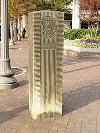
This picture is
|
|
|
One of the markers in the southern border to Virginia |
|
|
One of the Garden Club of America Entrance Markers in Friendship Heights (2005) |
| 10. |
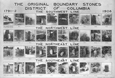
This picture is the: Enlarged 1908 composite photo by Ernest A. Shuster of the D.C. boundary stones and their sites
|
|
|
prior to fencing in 1915 |
|
|
in 1942 |
|